Texas Highways Network:

  • Interstate 10 Texas
  • Interstate 20 Texas
  • Interstate 35 Texas
  • Interstate 45 Texas
  • I-69 TTC News Blog

  •  
     
    i-35 Texas Traffic:

  • Dallas Traffic
  • Fort Worth Traffic
  • San Antonio Traffic

  •  


    i-35 Texas Maps:

  • Abbott
  • Abercrombie
  • Alvarado
  • Artesia Wells
  • Atascosa
  • Austin
  • Bellmead
  • Belton
  • Beverly Hills
  • Blue Mound
  • Bluff Springs
  • Botines
  • Bruceville
  • Buda
  • Burleson
  • Callaghan
  • Carl's Corner
  • Carrollton
  • Carter
  • Centex
  • Columbia Heights
  • Comal
  • Corinth
  • Corral City
  • Cotulla
  • Dallas
  • Del Mar
  • Denton
  • Derby
  • Desoto
  • Devine
  • Dilley
  • Eddy
  • Edgecliff
  • Elm Mott
  • Encinal
  • Eubank Acres
  • Farmers Branch
  • Forreston
  • Fort Sam Houston
  • Fort Worth
  • Fratt
  • Gainesville
  • Garden Acres
  • Gardendale
  • Georgetown
  • Grandview
  • Gribble
  • Heafer
  • Hewitt
  • Hickory Creek
  • Highland Village
  • Hillsboro
  • Hilltop
  • Hobbs
  • Hunter
  • Italy
  • Itasca
  • Jarrell
  • Kirby
  • Kyle
  • Lacy Lakeview
  • Lake Dallas
  • Laredo
  • Lewisville
  • Live Oak
  • Longhorn
  • Lorena
  • Lytle
  • Melody Hills
  • Midway
  • Milford
  • Millett
  • Moore
  • Natalia
  • New Braunfels
  • Northcliff
  • Northcrest
  • Oak Cliff
  • Ogden
  • Oldham
  • Onion Creek
  • Palo Alto Heights
  • Pearsall
  • Pershing
  • Pleasant Hill
  • Prairie Dell
  • Red Oak
  • Round Rock
  • Salado
  • San Antonio
  • San Jose
  • San Leanna
  • San Marcos
  • Sanger
  • Selma
  • Solms
  • Sterrett
  • Temple
  • Trinity Mills
  • Troy
  • Valley View
  • Von Ormy
  • Waco
  • Walnut Forest
  • Waxahachie
  • Webb
  • Wells Branch
  • West
  • Windcrest

  •  


    i-35 Texas Interstate 35 Texas Maps and Information ...
    i-35 Texas Interstate 35 Texas Maps
    Google


    Interstate 35 Texas ...


    Interactive map: click city names for more maps ...
    Interstate 35 Texas Map

    SEE ALSO: i-35 Dallas.com - i-35 Fort Worth.com - i-35 San Antonio.com
    The 
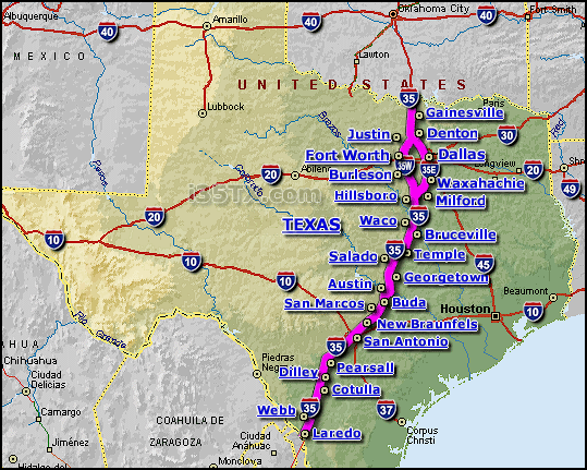
Interstate 35 in Texas, abbreviated "i-35 Texas" is a major Texas highway that travels generally in a north-south direction across the state of Texas. The map above shows the i-35 (highlighted in pink) where it travels across the state of Texas.

    The i-35 in Texas is very easy to navigate... it conveniently connects many dozens of Texas cities/communities along it's length, including the larger cities of Austin, Dallas, Fort Worth, San Antonio, and Waco... making the i-35 in Texas an important business corridor.

    As the i-35 travels into the Dallas-Fort Worth metroplex area, the i-35 splits into 2 sections; an East section (i-35E) and a West section (i-35W)... the east section (i-35 E) travels through the downtown Dallas area, and the west section (i-35 W) travels through the downtown Fort Worth area... as the i-35 leaves the Dallas Fort-Worth Metroplex area, i-35E & i-35W join back together again into the singular i-35.

    Within Texas, the i-35 in crosses/intersects several other major interstate highways, including; the i-10, i-20, i-30, i-37, and i-45.

    The i-35 Corridor is also a major transportation route for both people and cargo due to it's route that travels between the US/Mexico border and the Canada/US border.

    According to the software program Streets & Trips, the program calculates the length of the i-35 in Texas at approximately 492 miles long, with an estimated non-stop driving time of 7 hrs. and 57 minutes.
     

    SEE ALSO:

    i-35 Texas Sponsors

    i-35 Texas News Blog ...


    Loading...

    Visit the i-35 Texas news blog archive ...

    Visit the i-69 TTC news blog archive ...

    i-35 Texas Sponsors

    Copyright i35tx.com


    Video's:

    Loading...